Our land
Ever since man jumped into space. Since then, man has seen many astonishing wonders. One of these wonders is our own land. At first, the earth was considered flat. Because by that time neither man had gone into space, nor man-made satellites could go out of the earth and film it, nor were there telescopes with the help of which to see the structure of other planets etc. Any final theory about the ground structure can be put forward.
(It is not that nobody knew that the earth was round before the invention of space technology and telescopes. Was)
It is a natural aspect of man that he likes to prefer and confirm the appearance of anything. That is why when man first saw that the earth on which we live is holding us. Wherever we walk on it or travel (on animals, etc.), we see the earth flat in every direction from every place (in the past, people were afraid to travel more because of this.) So that when we travel somewhere we reach the end of the earth and do not fall “down”) So man considered it flat and for a long time the earth was considered flat.
Then the steps of man and man-made technology began to rise from the earth. Man jumped into the dark ditches of space. He traveled on unknown paths in space. Technology has come a long way. Spacecraft began to travel out of the earth and into space. While man witnessed many wonders with his own eyes, man also saw his home, the earth, with his own eyes from a distance of thousands, millions and crores of kilometers. The ground structure known in different ways was confirmed. That is, man saw his abode from the distances of space.
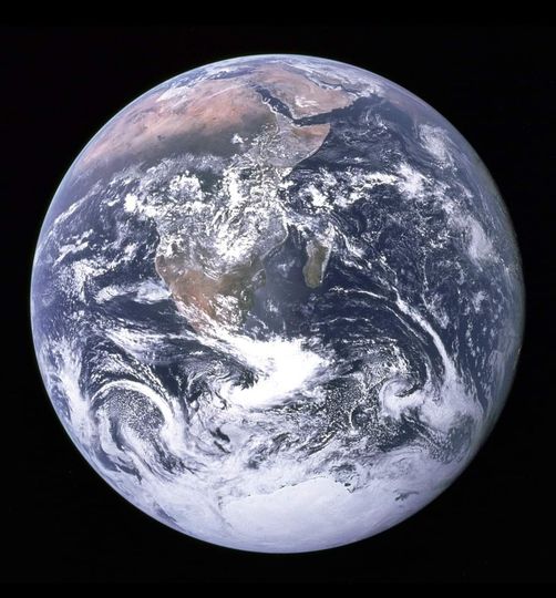
This image of the Earth under observation was taken in December 1972 by a camera from the Apoll 17 spacecraft on its way to the moon. This image of the Earth is considered to be the most unique and beautiful image in the history of space travel. This image was taken from a distance of 29,000 29,000 kilometers above the earth’s surface. This rare image of the earth was later renamed The Blue Marble.
The landscapes on the surface of this picture are described as “Arab countries at the top. You can also see a sea line separating Iran and Saudi Arabia. The section is called the Persian Gulf. Beyond that, between Saudi Arabia and Egypt and African countries, there is a sea called the Red Sea. The world’s largest desert is The Sahara Desert, which touches the borders of more than a dozen African countries, with a total area of more than 4.6 million square kilometers, followed by South Africa and its neighbors. The green area is the second largest “African jungle” in the world, with a green island in the sea. It is actually the African country of Madagascar.
Antarctica is the world’s largest glacier and the fifth largest continent in the world. The lowest temperature recorded in Antarctica is minus 89 degrees Celsius. The total area of the continent is just under 15 million square kilometers. Out of such a vast region, only 280,000 square kilometers are free of snow. The rest of the region is covered with snow. These are our clouds that look like cotton wool above the ground. Who orbit the earth all the time.”
This picture is a unique and beautiful picture of our earth. This is also a very important picture, do you know why it is important?
Because in this picture, I am writing this article sitting on the same planet and you are reading this article sitting on the same planet